

UAF photo by JR Ancheta.
Mount Edgecumbe volcano, located about 10 miles across Sitka Sound from the city of
Sitka, reawakened in early 2022. The volcano is shown in this June 3, 2023, photograph.
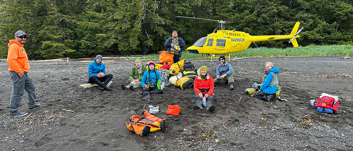
SITKA, Alaska — In short, quick round trips of about 20 miles, helicopter pilot Tarek Husevold ferried an international team of six scientists, their two chroniclers and loads of science instruments and survival gear across Alaska’s Sitka Sound daily in early June.
The destination was Kruzof Island. The purpose was to study Mount Edgecumbe volcano, which rises to 3,202 feet. No humans live on Kruzof Island. Hundreds of brown bears do.
Husevold flew the chartered yellow Bell 206 B III low across the water several times a day through most of the weeklong fieldwork campaign, carrying varying combinations of people and cargo and always flying near some of the dozens of rocky and tree-laden islets marking the east side of the waterway. Water temperature in the sound is an uncomfortable and hazardous 45 degrees or so in early June.
Mount Edgecumbe volcano reigns over the island’s landscape and Sitka, the long-ago capital of Russian Alaska headquartered on Baranof Island. Clouds regularly conceal and then reveal the summit of L’ux Shaa, the regional Lingít language name of Mount Edgecumbe.
Whether the summit crater would remain anything other than a large bowl of snow and ice likely received little thought in Sitka and beyond.
That changed in April of last year.
A science opportunity
The Alaska Volcano Observatory quickly reported to the public in April 2022, after a rapid analysis, that Mount Edgecumbe volcano had awakened.
“A swarm of earthquakes was detected in the vicinity of Mount Edgecumbe volcano beginning on Monday, April 11, 2022,” the AVO’s notice read. “The recent swarm inspired an in-depth analysis of the last 7.5 years of ground deformation detectable with radar satellite data. Analysis of these data from recent years reveals a broad area, about 17 km (10.5 miles) in diameter, of surface uplift centered about 2.5 km (1.5 miles) to the east of Mt Edgecumbe.”
“The coincidence of earthquakes and ground deformation in time and location suggests that these signals are likely due to the movement of magma beneath Mount Edgecumbe, as opposed to tectonic activity…. Intrusions of new magma under volcanoes do not always result in volcanic eruptions. The deformation and earthquake activity at Edgecumbe may cease with no eruption occurring.”
The volcano quickly became a target of intense research, giving scientists in Alaska and beyond the rare opportunity to study a slowly reawakening volcano.

Társilo Girona, (left) a research assistant professor at the UAF Geophysical Institute, and Claire Puleio, Girona’s Ph.D. student, check out a forward-looking infrared camera on June 3, 2023. Puleio is co-leading the research as part of her doctoral work.
In June of this year, funding by NASA and by institutions in Spain and Italy supported an international team led by University of Alaska Fairbanks scientists to investigate one aspect of the revived volcano. The NASA funding is through the agency’s Earth Science Division and came in a grant awarded to Társilo Girona, a research assistant professor at the UAF Geophysical Institute, through the Early Career Investigator Program in Earth Science.
In addition to Girona, science team members included Claire Puleio, Girona’s Ph.D. student who is co-leading the research as part of her doctoral work; Taryn Lopez, Geophysical Institute research associate professor; Valerie Wasser, Lopez’s Ph.D student; Carlo Cardellini, associate professor in geochemistry at the University of Perugia in Italy; and David Benavente, professor of chemistry and metallurgy at the University of Alicante in Spain.
“This is a challenging project,” Girona said at an evening group discussion about plans for the next day, their first on the island.
An unnerving welcome
Before the science could begin on this particular Sunday morning in early June, the first day at Kruzof Island, there was the matter of what to do about the bear.
The science team knew in advance that encountering a bear was always a possibility. Each team member attended bear awareness training before heading to Sitka and would carry bear deterrents while on the island.
On the first day in the field, a brown bear of moderate size was near the proposed helicopter landing site on the second flight of the day. The two Ph.D. students — Puleio and Wasser — were already on the ground with some science instruments.
They didn’t know about the bear.

This brown bear was sighted near where some members of the science team were being dropped off on the first day on Kruzof Island.
“When the helicopter was coming in with the second group of people,” Puleio said later, “we got the radio call from the pilot, who said, ‘There’s a bear really close to you. Kind of around the corner. I think maybe 100 yards away, pretty close,’ which we didn’t know.”
The incoming helicopter carried the second pair of scientists. All three on the helicopter saw the bear.
“We doubled back around and tried to scare it into the woods,” Husevold said. “It ran back in and didn’t go very far. It hid behind a bush and just hung out.”
“We came back a few times to see if we could get him to go into the woods a little further,” he said. “But he just kept hiding behind that bush.”
The helicopter dropped the next two scientists, for a total of four on the ground. Two more, plus the Geophysical Institute’s two-person information team, were at Sitka awaiting their turn.
The third flight carried Girona and Benavente. With four scientists on the island’s rocky shore and a bear in the vicinity, tension filled the radio airwaves between helicopter and island.
“In that flight, the pilot realized that the bear was getting closer and closer to the landing spot where the others were, instead of the opposite,” Girona said. “That was the really scary thing and is what made me decide to move everyone.”
“The decision process was intense,” he said. “The pilot was concerned because the bear moved quite a bit toward the team with respect to the previous flight. He told me: ‘You decide what you want to do with your team.’”
With adrenaline and awareness running high, Girona decided to have the team pack up and make a short helicopter hop to another of the predetermined study sites.
“My concern was for the safety of everyone,” he said. “So I made the decision to move.”
The encounter was new for Husevold, who has been flying for 15 years.
“This is actually the closest one I’ve ever seen,” he said.
About 1,000 brown bears inhabit Kruzof and Baranof islands combined, according to the Alaska Department of Fish and Game. The department considers the two islands as a single management area. The islands have no black bears.
Bears would remain on each team member’s mind throughout the fieldwork. The regular sounds of their bear deterrents — Girona’s air horn and each team member’s kazoo-like noisemaker — testified to the worry. And each person’s bear spray and InReach communication device were always at hand.
An awakened volcano
Mount Edgecumbe, or L’ux Shaa, last erupted about 800 years ago, according to a Lingít oral history handed down by Tlingit elder Herman Kitka. Lingít is the language of the Tlingit people, who have lived in what is now Southeast Alaska for at least 10,000 years.

The red area on the map shows up to 10.6 inches of ground uplift. The time series shows deformation at map locations 1 through 4. The vertical line shows the onset of deformation in August 2018.
In Kitka’s telling, a group of Tlingits in four canoes had camped on the coast about 15 or 20 miles south of some large smoke plumes. A scouting party in a canoe was sent to investigate the smoke and reported “a mountain blinking, spouting fire and smoke.”
Nearly a century removed from that telling, scientists in April of last year were poring over the past seven and a half years of satellite-based ground deformation analysis for information about the new activity. That analysis showed a wide area of uplift, about 10.5 miles in diameter to the east of the volcano and down to near sea level, that began in August 2018.
Researchers determined that magma had risen to about 6 miles from a depth of about 12 miles and caused the earthquakes and surface deformation.
Information gained during June’s weeklong field campaign and an August return trip by Puleio and Laura Clor, a volcanic gas geochemist with the U.S. Geological Survey’s Volcano Emissions Project based at the Cascades Volcano Observatory, will add insight to the volcano’s behavior. Initial findings and analysis will likely be known by the end of 2023.
The Alaska Volcano Observatory now considers Mount Edgecumbe volcano to be historically active based on the significant ground deformation that has been measured, according to David Fee, the observatory’s coordinating scientist. The upward deformation began abruptly in August 2018 and continued at a rate of 3.4 inches annually, for a total of 10.6 inches through early 2022.
Scientists note that Edgecumbe currently poses no immediate eruption threat.
The research in June was not directly associated with the Alaska Volcano Observatory, which is located at the UAF Geophysical Institute. The observatory is a joint program of the Geophysical Institute, the U.S. Geological Survey and the state of Alaska Division of Geological and Geophysical Surveys.
Four members of the fieldwork team on the June trip are part of AVO, however.
Observatory team members from UAF and from the state and federal agencies in August placed additional seismic and GPS stations on the volcano.
The research aim

Carlo Cardellini, associate professor in geochemistry at the University of Perugia in Italy, explains the underside of a carbon dioxide accumulator.
The goal of the June research trip: Measure ground carbon dioxide emissions at the Mount Edgecumbe crater rim, at an adjacent ridge and at sea level. The CO2 measurements will be compared to years of satellite data indicating temperature anomalies at the sample collection sites. Aside from magma and tephra — rock fragments and other particles — volcanoes emit mostly water vapor, carbon dioxide and sulfur dioxide.
“If you go to the beach and put thermometers there, you’re not going to be able to see subtle geothermal anomalies,” Girona said.
“However, with remote sensing data analysis, we are able to see areas that are more prone to show geothermal anomalies than others,” he said. “And we want to see if those areas that are more prone to show anomalies correspond to a higher release of diffuse CO2 through the ground.”
Puleio said the anomalies are subtle temperature changes that happen over the course of months or years.
“What we have seen over the last 20 years of analyzing Mount Edgecumbe is we do see some temperature anomalies, some very, very slight temperature anomalies along some of the beaches, mostly in the southeast portion of the island,” she said.
The central instruments on this trip were the carbon dioxide accumulation chambers, which look somewhat like a stovetop pasta pot but with an open bottom. The collectors gather air, filter out dust and other particles, then send it to a unit for measuring the amount of CO2 present and determining the rate at which it emitted from the ground.

University of Alicante professor David Benavente, front, and University of Perugia Department of Physics and Geology associate professor Carlo Cardellini measure the depth, pH and temperature of a bubbling pond near Mount Edgecumbe volcano on Kruzof Island on June 9, 2023.
Another surprise
Something much smaller than a brown bear also caused excitement on the first day on the island.
Bubbles.
Intermittent streams of small bubbles, perhaps no larger than a nickel each, wiggled to the surface in four places at an oceanfront pond. The team chose this as a study site after hearing of it from a Sitka resident who reported seeing bubbles.
The pond, about 150 feet across and bordered on its inland half by a jumble of whitewashed logs, quickly became an area of intense interest. And that meant breaking out the inflatable canoe to reach the bubbles to try to capture their content with a CO2 chamber, record the temperature and acidity of the water and collect a sample for analysis.
CO2 collectors don’t float, so a little improvising was needed: Girona, Benavente, and Cardellini outfitted a collector with a light blue blow-up swimming ring designed for babies and covered with images of shells, seahorses and starfish.
“The day has been very exciting so far,” Girona said in the afternoon as activity continued around him and with Cardellini reading out GPS coordinates from the kayak. “But the morning with the bear was a bit stressful.”
The two-person canoe proved too difficult to keep in one spot long enough for the science instruments, however. With time running out on the day, the team would need to come back with another plan.
Bubbling Pond, as it was called, would remain a point of interest throughout the research period.

Carlo Cardellini (left), associate professor in geochemistry at the University of Perugia in Italy, and Taryn Lopez, UAF Geophysical Institute research associate professor, take CO2 and other measurements in a pond emitting a sulfur smell on June 4, 2023.
The pond wasn’t the only bubble sighting of this first day, however.
Bubbles percolated briefly in the shallow brackish water of a nearby narrow finger of water bordered on each side by slabs of old lava. A sulfur scent came intermittently as Cardellini captured air in the collector and read data to Lopez.
In addition to collecting CO2 samples, the team was eager to get a helium sample.
While carbon dioxide can be present from geologic processes or biological sources, the isotopic composition of helium at the pond can help confirm a geologic gas source.
Naturally occurring helium-4 accounts for nearly all of Earth’s helium. Helium-3 accounts for only about one ten-thousandth of total helium. It is primordial, meaning it was trapped in Earth’s mantle during the planet’s formation.
Knowing the ratio of helium-4 to helium-3 in a sample can help determine the source.
“If it has a mantle component, we can assume it is related to volcanic activity,” Cardellini said. “Whether it’s a magmatic gas or an absence of magmatic gas, both are important results.”

UAF Ph.D. student Valerie Wasser, left, records atmospheric and soil data as fellow Ph.D. student Claire Puleio uses the carbon dioxide accumulator on June 5, 2023.
Beachcombing for carbon dioxide
The full science team spent several days along the shoreline with the carbon dioxide collectors, partly due to weather that limited helicopter flights to the crater. Three pairs of scientists would walk in parallel lines along the predetermined beach sites, stopping roughly every 150 feet to take measurements.
“We’ll take a gas sample, and then we’ll be able to do a carbon isotope analysis on that gas sample, which will let us know if the origin of the CO2 is from a biological source or magmatic,” Puleio said.
On a cool and damp Monday, day 3 of the fieldwork campaign, the scientists worked along a curving section of beach. Eagles glided above. Hoofprints in the sand below told of visits by Sitka blacktail deer.
On this day, a cool and damp Monday, day 3 of the fieldwork campaign, the scientists worked along a curving section of beach.
The three teams, spaced equally apart up the roughly 500 feet from the incoming tide to the grassy skirt in front of the thick hemlock and Sitka spruce forest that reaches up the slopes, repeated the process for nearly a mile.
Walk, stop, measure.
Walk, stop, measure.
At every stop on this site named by the team as “Beach 2,” one team member placed the 12-inch diameter accumulation chamber gently onto the sand. A pump, humming steadily from within one scientist’s backpack, moved the collected air to the CO2 sensor.
The second scientist had several tasks: plunging the two short probes of the soil moisture meter into the ground, inserting another to record temperature just below the surface and again at the probe’s full 4 ½-inch depth and using another device to record air temperature, maximum and average wind speed and air pressure. All of that data is needed because those factors can influence CO2 emission.
Carbon dioxide quantity is measured in the number of grams per square meter per day. The resulting number is referred to as flux.
Flux readings at this strip of beach weren’t impressive, but they nevertheless have potential use as a baseline against which measurements made elsewhere during this research can be compared.
“In any kind of survey, it’s important to know what is normal,” Cardellini said. “It is also called geochemical baseline or background values.”
Cardellini explained that the scientists can determine the CO2’s source — biogenic or magmatic, as Puleio noted — by determining the carbon’s isotopic composition. Carbon-12 accounts for nearly 99% of all carbon on Earth. Carbon-13, which has one more neutron per atom, is relatively more abundant in volcano emissions.
The ratio of carbon-12 to carbon-13 in a gas sample can provide additional information about the source of CO2 — whether it is from a “primitive” mantle like that of mid-oceanic ridges or whether it has also been contributed by recycling of carbon from sediments and rocks as occurs in subduction zones.
Carbon dioxide can also be produced by “metamorphic” reactions occurring in the rocks surrounding the magma or by reactions occurring in a hydrothermal environment that can be present between the deep magma and the surface.
“In a volcano you can have carbon dioxide also from quite different sources,” Cardellini said at the Sitka airport as the sound of the returning helicopter’s rotor blades grew louder.

The Mount Edgecumbe science team gathers on an old lava outflow in southern Kruzof Island on June 8, 2023.
Kruzof Island’s beaches varied, all with a typical sandy front but many with thick lava bed remnants. Ponds and small pockets of water dotted the shorescape. Sun-bleached logs and a ribbon of grass marked the separation of beach from forest.
“There are lots of lava flows,” Puleio said. “So we’re walking over really interesting rocks with some beautiful textures.”
These first three days of the field research were aided by good weather in the oft-rainy Sitka region.
“Yes, I think things have been going well,” Girona said.
The science team has lunch on June 10, 2023, on Kruzof Island. UAF Geophysical Institute photographer JR Ancheta is in the rear. Helicopter pilot Tarek Husevold is at left.
Eruption history
On a Thursday, day 5 of the fieldwork, Husevold guided the bright yellow four-seat helicopter — but on this fieldwork really a three-seater plus loads of science and survival gear — to a spot not far from one of the chosen study areas. This was “Degassing site 1.”
The helicopter’s skids gently touched down on a mostly flat surface on the collection of blocks, slabs and sheets of dark gray rock. The surface consists of a plagioclase basalt lava flow from sometime in the Pleistocene Epoch, which ended 11,700 years ago.
Mount Edgecumbe itself is part of a larger geologic construction known as the Mount Edgecumbe Volcanic Field, which includes about two dozen vents. It is dominated by Mount Edgecumbe stratovolcano, a conical volcano formed of layers of thick lava and other material ejected during an eruption, and the adjoining Crater Ridge a mile distant to the northeast.
Farther away to the northeast, yet still part of the volcanic field, is the much smaller Shell Mountain at 5.5 miles from Edgecumbe. Shell Mountain is a stratovolcano rising to just 1,608 feet, half the height of Edgecumbe.
Mount Edgecumbe’s crater is about half a mile across, whereas the cavity from the massive explosion at Crater Ridge is 1 mile wide. Shell Mountain’s crater is about 1,100 feet wide.
The Alaska Volcano Observatory lists several Mount Edgecumbe eruptions: an explosive eruption approximately 4030 before present to 4310 BP, an explosive eruption at approximately 5760 BP, an explosion and mudflow at approximately 9000 BP and an eruption at approximately 11250 BP.
The AVO also states that eruptions 13,000 to 14,500 years ago produced at least one widespread regional tephra, or ash, layer around 1 meter thick near Sitka and over 30 meters thick on parts of Kruzof Island.
Volcanic activity originated about 600,000 years ago along fissures cutting across the 167-square-mile island, according to data assembled by the Smithsonian Institution’s Global Volcanism Program.
Edgecumbe sits on the North American plate 6 to 9 miles east of the Queen Charlotte-Fairweather fault, which separates the North American plate from the Pacific plate.

Társilo Girona (right), a research assistant professor at the UAF Geophysical Institute, speaks during the regular evening meal and science discussion on June 7, 2023. Girona obtained the Mount Edgecumbe research funding through the NASA Earth Science Division’s Early Career Investigator Program in Earth Science.
Science and supper
Each night, with the day’s science work done, the team gathered for dinner and discussion of the day’s work and plans for the next day.
Each night throughout the fieldwork campaign, except for two nights at local restaurants, a team member would take a turn preparing dinner for all with help from a colleague. The fare on day 7: spaghetti with tuna and cherry tomatoes, prepared by Cardellini.
On this night, the discussion had a sense of urgency. Only two days remained before the fieldwork would end, and the weather, particularly on the island, changes rapidly.
With only two days remaining until the team was scheduled to leave Sitka, the talk was intense. Numerous plans were discussed for how best to deploy the six scientists: Should some go back to Bubbling Pond? The team still hoped to get a helium sample. What if some could get to Edgecumbe’s flank, which had yet to be sampled? What about visiting a beach site that the team hadn’t yet visited?
The group knew that any plan depended on the weather. And on Husevold, their helicopter pilot.
Science at times punctuated the debate on who should go where. There was a question regarding carbon isotopes:
Lopez: “There is one complication we haven’t talked about. It’s possible there’s crustal carbonate here. …You can get a signal that looks like mantle, but it also could be mixing between sediment and carbonate. Knowing the helium isotope will help us.”
Cardellini: “Helium would be very helpful for modeling.”
Wasser: “How much more helium do you think comes out? How much more can we actually collect?”
Cardellini: “The helium will be very low, but it depends on the isotopic composition. If we get enough helium in the sample to get the isotopic composition, it will indicate if this is magmatic.”
Puleio: “What volume percent of helium will we need to get enough to get to the isotopes?”
The helium talk continued, went into a discussion of methods, and then back to planning for the next day’s fieldwork.

Some members of the international science team can be seen to the right of center on the foreground ridge of Mount Edgecumbe volcano on June 7, 2023.

A screenshot of a smartphone app shows part of a helicopter reconnaissance flight in and around the Mount Edgecumbe crater on June 7, 2023.
The summit
The crater was calling.
Girona, Puleio and Wasser were on the summit. Husevold had dropped them off after flying in expanding concentric circles so the team could look for heat signatures through use of forward-looking infrared radar. They also scouted possible landing spots on the volcano’s flanks for mid-elevation measurements.
On that day, Wednesday, the weather was holding — for the moment. When the summit opened through the clouds, and with Husevold agreeing it looked good, the team knew it was time to go.
They didn’t want to miss the chance, knowing it might not come again.
Husevold ferried everyone to a landing spot at the lower edge of the tilted crater’s rim at about 2,900 feet. Snow painted the crater walls and floor, but only lichen and gray and black rocks and pebbles covered the flattened rim.
As they did on beaches and ponds below, the science team took carbon dioxide at atmosphere readings around the rim. Areas of snow melt near the crater’s center would become a discussion point at the nightly dinner: Were they caused by the sun or by heat from below?
Time was short, however. The weather was changing.
“It’s really motivational to actually see the volcanoes you’re studying,” said Wasser, who has also been on Alaska’s Pavlof and Augustine volcanoes.
The Edgecumbe summit was Puleio’s first volcano crater.
“A lot of the work I do is behind a computer screen, so this is a wonderful time to put that into practice and see what this means in the real world,” she said. “It’s a great hands-on experience.”
Rod Boyce is a science communicator for the University of Alaska Fairbanks Geophysical Institute.
