Photo courtesy of Zac Smith and Fresh Eyes on Ice.
Drone footage of the 2022 Sleetmute flood on May 8, 2022, shows the water overtaking
the houses and flooding the community.
By Grace Veenstra
Half the year, the Kuskokwim River’s surface at the village of Sleetmute freezes solid, with the ice reaching more than a foot thick by winter’s end. Then, each spring, ice chunks the size of cars grind their way downriver, tearing trees from the banks by their roots. But the river's power can readily turn even more dangerous.
In the past several years, Sleetmute has been among dozens of Alaska communities flooded during the spring breakup of river ice.
“We’ve had several minor floods that have simply displaced items in our yards,” said Angela Hayden ’17, ’18, a teacher in Sleetmute. “The most recent flood, in 2022, caused more severe damage because the water level rose to the bottom of some of the houses, ruining their foundations and the insulation.”
In spring of 2023, catastrophic flooding also hit Circle on the Yukon River and Crooked Creek on the Kuskokwim. In Circle, water levels reached historic heights. Dozens of homes and buildings were destroyed or suffered major damage.
Diane Olmstead, a teacher in Circle, described how the flood arrived on May 13, 2023.
“At first, everyone was in a celebratory mood down on the river’s edge,” she said in an email. “There was a section of the river ice that was flowing fast in the middle of the slough in front of Circle. No one was concerned.”
But as the evening wore on, she looked out her window to see water flowing up the road.
“I was in disbelief,” she said. “I was under the false impression that there would be a warning system, even though I knew no one ever said there was one in place. How hard would it have been to have a siren go off?”
Olmstead began throwing things into her car as the water reached her car’s wheels and continued rising. She and others went to the school, thought to be higher ground and 6 feet above where she’d first seen the floodwaters, but in less than half an hour the water had already reached them again. Olmstead and her colleagues climbed the school steps to take shelter in the building. Around 10 p.m, Olmstead said the water was lapping at the bottom of her car windows, the highest the water got. By the next morning much of the water had drained off.
“We walked around the school grounds,” Olmstead said. “A massive 10-foot-tall iceberg the size of an oversized semi truck was resting in the parking lot. Other huge icebergs were resting everywhere we looked. The duplex of teacher housing was knocked off its foundation and moved 20 feet to the north.”
Like so many communities in river country, Sleetmute and Circle know the consequences of flooding. To prepare for the next flood, many of these communities are working with researchers and forecasters in Alaska and beyond to improve the ability to predict when floods will happen and how bad they will be.
What causes breakup floods?
In Alaska, the most significant spring flooding results from ice jams, which occur when floating chunks of ice accumulate and clump together. Ice jams can significantly reduce water flow and cause upstream flooding and, in some cases, downstream flooding as backed up water spills over the riverbank.
Scott Lindsey, who is now the director of the National Weather Service’s Alaska region, described the two types of breakups in a 2019 article in Alaska Park Science, a series produced by the National Park Service.
The first is known as thermal breakup, where the ice becomes soft and weak, thanks to slowly increasing temperatures, and breaks apart without resistance, Lindsey explained. This type of breakup is unlikely to form an ice jam, since the ice is not solid enough to stick together.
However, the second type of breakup, known as dynamic or mechanical breakup, is the one forecasters and communities watch out for. In a dynamic breakup, the ice remains hard and resistant to breaking. Dynamic breakup can result from high levels of snowpack, significant ice thickness and a rapid increase in temperatures, Lindsey said.

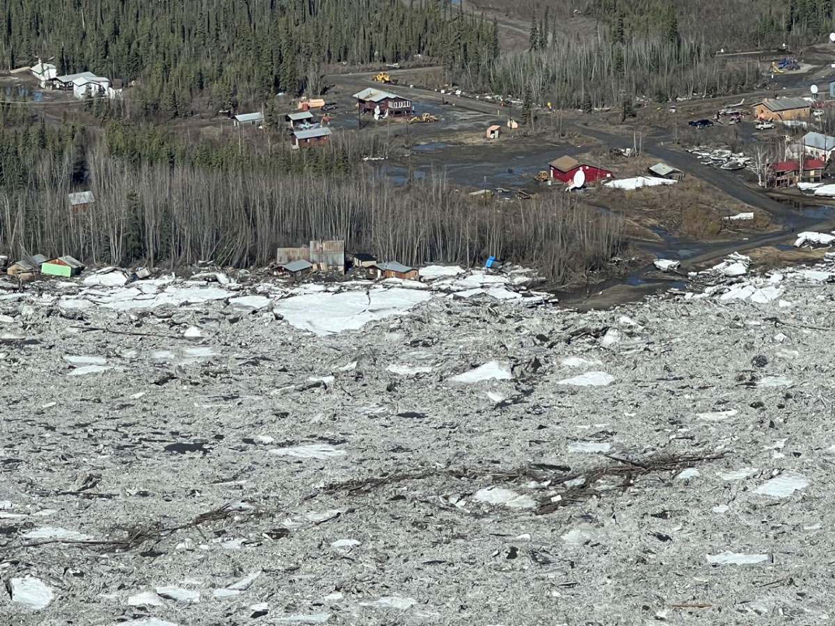
An aerial photograph of the 2023 Circle flood on May 14, 2023, shows the ice onshore and damaged houses.
When the ice does begin to move in a dynamic breakup, it typically remains in large sheets that are easily snagged on sandbars, on bridge pilings or in slower water close to shore, he noted. River ice jams typically occur at pinch points, such as at sharp bends and places where the channel constricts. Like trying to shove a square peg in a round hole, the ice piles up and prevents water from moving downstream. Water upstream of the jam can rise rapidly, flooding communities.
Aside from the rising waters, the ice itself can be a hazard. Large sheets of ice can be carried on shore and bulldoze anything in their path, leveling trees and buildings. In 2009, the Yukon River community of Eagle experienced a major flood. Some buildings had water up to the second story, and house-sized chunks of ice swept through the small town.
Ice jams cannot be prevented, so Alaska’s many remote river communities focus their attention and resources on preparation, prediction and response.
Forecasting flooding

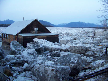
Car-sized chunks of ice move into the community of Eagle during the 2009 spring breakup flood.
An arm of the National Weather Service, the Alaska-Pacific River Forecast Center, serves as the cornerstone of flood prediction work in Alaska.
“Year-round, we’re responsible for flood forecasting and providing watches, warnings and advisories for all communities in the state of Alaska,” said Celine van Breukelen ’10, a service coordinator at the center in Anchorage. “We work with the individual communities, because they know what’s going on in their backyard, how the winter has been and how things are progressing,”.
The center alerts communities to their flood risk a few weeks in advance of breakup so they have time to prepare. In 2023, the entire state had an above-average risk for spring breakup flooding due to the high snowpack and unusually cold April.
“As the breakup season moves into being more active, we have people flying in small aircraft over the communities and reporting directly to those communities along with emergency managers,” van Breukelen said. “We’re also in the office looking at satellite imagery and hydrographs, and scraping data wherever we can get it.”
The forecast center also works with a variety of partners to be able to predict flood events. Satellites are among their biggest assets.
“We use a lot of satellite imagery, and that's become more and more available in recent years,” van Breukelen said.
Data from the European Space Agency’s Sentinel satellite is the most preferred at the forecast center. The satellite provides high-resolution images accessible by the public. Among these is the true color imagery, which is similar to what the human eye would see from space, and false color imagery, which assigns different colors — such as dark blue for snow or cyan for cloud cover — to highlight different features.
The forecast center also uses data and products from other satellites, including some operated by the National Oceanic and Atmospheric Administration.
William Straka III works at the Cooperative Institute for Meteorological Satellite Studies at the University of Wisconsin. He develops algorithms that process satellite data and turn them into products that forecasters such as van Breukelen can use. Despite being over 2,000 miles from Alaska, Straka’s work is very relevant to Alaska communities.
“Ground-based instruments provide a local, point-based set of information, whereas satellite data can provide you a very, very large scale observation of an area,” Straka said.

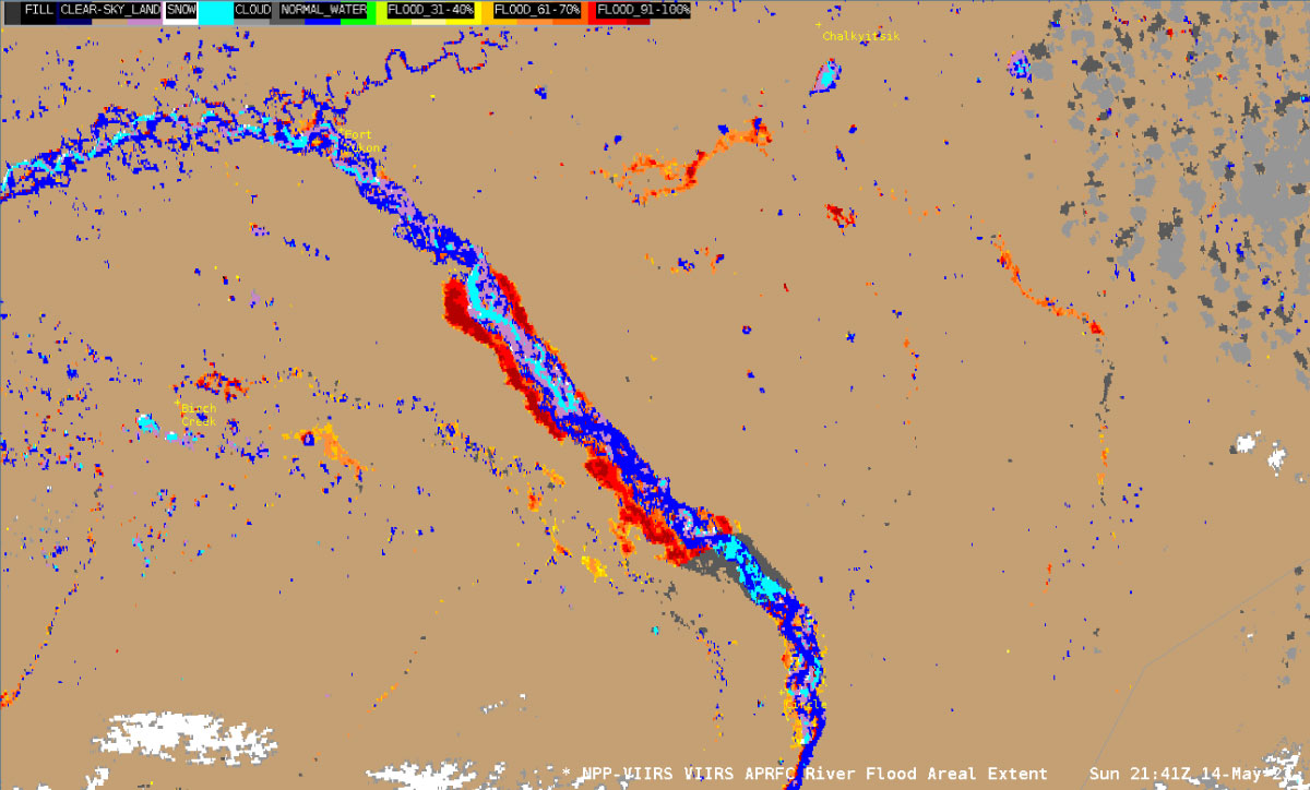
A satellite image from the VIIRS River flood product shows the flooding of the Yukon River between Fort Yukon and Circle on May 14, 2023, when Circle was flooded due to the ice jam downstream.
Straka works with the Alaska-Pacific River Forecast Center to provide daily notes on the satellite data during breakup. One source he watches is a product created with an instrument called the Visible Infrared Imaging Radiometer Suite, which operates on NOAA’s Joint Polar Satellite System. The “VIIRS flood product” is akin to a map depicting where water is and may be, and is produced by Straka’s institute and the Geographic Information Network of Alaska at UAF.
Sanmei Li of George Mason University developed this VIIRS product partly in response to the 2013 flood in Galena, Alaska. That Yukon River flood displaced nearly all 472 residents as 7 to 9 feet of water overtook homes and businesses.
“The VIIRS flood product measures how moist the land is compared to normal,” Straka said. “The more moisture that you see, the more likely it's flooded. If you're getting upward of 60 to 90% moisture, you probably don't have mud there, you have water there.”
With the aid of satellite imagery from Sentinel and the VIIRS, the Alaska-Pacific River Forecast Center can see far more of the state.
Community-based observations
Facebook has many public and private groups of community members from across Alaska who share information about the behavior of ice. One of these groups belongs to Fresh Eyes on Ice, a UAF project that focuses on improving observations and understanding of freshwater ice.
Fresh Eyes on Ice uses a variety of tools, such as buoys and satellite data, much like the Alaska-Pacific River Forecast Center. But one of its most notable features is the inclusion of citizen science and community-based monitoring teams.
“The community-based monitoring teams are comprised of educators, long-term community members and youth who work together to make monthly measurements of ice thickness,” said Katie Spellman ’08, ’15, an assistant professor at the UAF International Arctic Research Center. Spellman specializes in citizen science and is part of Fresh Eyes on Ice.
One of these community-based monitoring teams is in Sleetmute. During the winter, Hayden, the teacher, takes her students out to measure the ice on the Kuskokwim River.
“Fresh Eyes on Ice helps the students realize they are a part of something bigger and that their citizen science skills benefit their community and the world,” Hayden said. “It also helps them be aware of the environment around them and makes them feel like they are a part of the future.”
The tools Hayden’s class uses for ice monitoring aren’t complex instruments. They can be bought at a general store in town.
“Ice augers and rulers, that’s pretty much it,” Spellman said.
Aside from recording measurements of ice thickness, Fresh Eyes on Ice is also an avenue for community members to share photos of the ice outside their homes. Those photographs are shared with the Alaska-Pacific River Forecast Center and the National Weather Service.
“There’s so much more people power in inviting everyone to the table to submit photos of changing ice conditions,” Spellman said. “That’s why community and citizen science is a good approach, because everybody has a phone now and everybody can take a picture.”
Whether through the Fresh Eyes on Ice Facebook page or its photo-submission form, these photos are vital to predicting breakup flood events. They help communities in the present by informing others along the river of potential flood hazards, and they will help forecasters predict flooding in years to come.
For example, Straka uses the photos submitted through Fresh Eyes on Ice to improve the satellite products he works on.
“That's very important,” Straka said. “The algorithm's good, but you want verification and validation of the algorithm. If you don't validate your algorithm, you don't know how accurate it is.”
People like Straka and the forecast center employees aren’t the only ones predicting breakup flooding; the communities themselves also try.
Student-based science

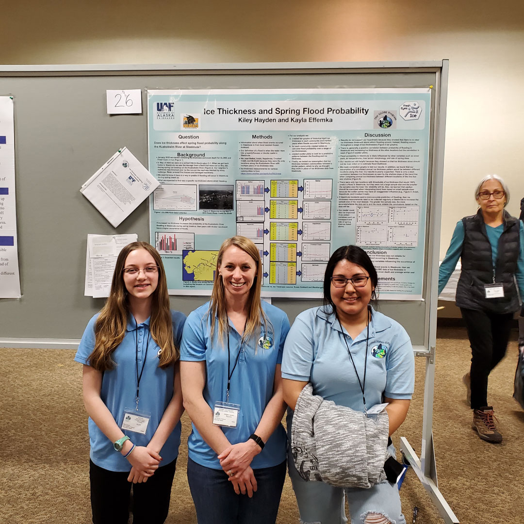
Kayla (right) and Kiley (left) with their teacher Angela Hayden (center) stand in front of the students’ poster at the GLOBE Student Science Symposium
Kayla and Kiley, high school students from Sleetmute, witnessed the aftermath of the 2022 flood. The girls were on a class trip at the time, but upon their return they could see the flood's impact.
“The dump got flooded, and there was trash a quarter mile away,” Kayla said. “I could also see scratches on the trees from the ice.”
Kiley said the water rose until it was a couple feet from the steps of her house. She spent time that spring picking up her dad’s firewood that floated away with the water. One neighbor's old outhouse floated off its foundation, and another neighbor had an all-terrain vehicle whose engine was flooded.
After the 2022 flood, the girls wondered if they could use ice thickness measurements to predict the probability their community would flood. They found a historical record of spring flood events in Sleetmute collected by resident Susan Hubbard. They also obtained ice thickness measurements from the National Weather Service for other communities along the Kuskokwim.
But they found little relationship between ice thickness and flood probability.
The two presented their findings several times, including at the GLOBE Student Science Symposium in Fairbanks, alongside many other youth community members with their own projects.
While Sleetmute escaped breakup flooding in 2023, other communities such as Circle and Crooked Creek were not so fortunate.
“I heard about one fourth of the village was affected by the flood,” said Olmstead, the teacher in Circle. “Those who lost their homes were given temporary trailers.”
Olmstead herself stayed in Fairbanks after the flood.
“I wish there had been a siren to alert me to the impending water,” she said. “I might have been able to save my car and my possessions that made it in the car… But, sadly, the severity of the situation never made it to me.”
While Circle’s flooding occurred nearly a year ago, people are already preparing for the coming spring and the potential flooding it could bring. Straka will continue to refine his models, and the Alaska-Pacific River Forecast Center will continue to watch the river, ready to inform Alaska of how its rivers are behaving.
“Our goal at the end of the day is to give communities the best possible information so they can make the best decisions,” van Breukelen said.
If you want to help with flood watch efforts in Alaska this spring, consider submitting photos to Fresh Eyes on Ice!
Grace Veenstra is a student at the University of Alaska Fairbanks and is employed by the Geographic Information Network of Alaska at the UAF Geophysical Institute.


