

GINA captures smoky images of Alaska's Interior
GINA captures smoky images of Alaska’s Interior
Submitted by Amy Hartley
Phone: 474-5823
08/17/05
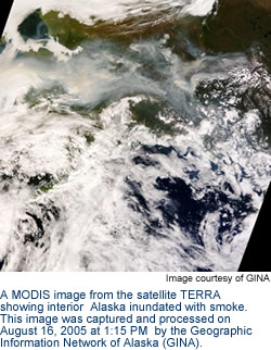
The dense band of smoke that’s stretched across Alaska’s Interior is visible from satellites in space . The Geographic Information Network of Alaska (GINA) at the University of Alaska Fairbanks Geophysical Institute is capturing some of these images and providing them to fire personnel. In addition, the public may view some of the images online through the GINA Web site at http://www.gina.alaska.edu.
GINA is currently collaborating with a number of agencies to provide near-real-time satellite data to the Bureau of Land Management’s Alaska Fire Service. Armed with images taken from space, fire personnel is able to track hot spots and fire movement, even under heavy smoke that may ground mapping aircraft. Data from Landsat 5 and MODIS satellites is made available to fire crews and other users in less than 24 hours through the GINA network.
This is the fourth season MODIS satellite data will provide information to fire personnel through GINA. The entire state of Alaska can be viewed in one pass by MODIS satellites, which makes several passes each day. Due to the satellites’ multiple spectral bands, GINA is able to supply users with natural color images of smoke and terrain, as well as thermal images. MODIS images and fire detection points are processed by GINA and delivered to agencies within 40 minutes of reception.
GINA, a facility at the Geophysical Institute, was established in 2001 as the University of Alaska’s mechanism for organizing and sharing diverse geospatial data and technological capabilities.
VIEW CURRENT SMOKE IMAGES ONLINE: http://www.gina.alaska.edu/page.xml?group=data&page=alaska_images
CONTACT: Tom Heinrichs, GINA Technical Services Manager:(907) 474-6897. Amy Hartley, Geophysical Institute Information Officer: (907) 474-5823.