

Campaigns begin for Geophysical Institute's unmanned aircraft system
Campaigns begin for Geophysical Institute’s unmanned aircraft system
Submitted by Amy Hartley
Phone: (907) 474-5823
06/28/07
FOR IMMEDIATE RELEASE
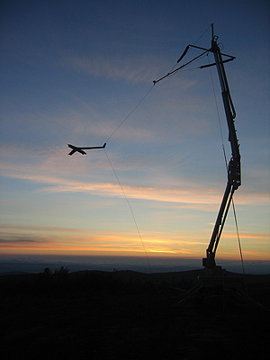
FAIRBANKS, Alaska--Logging more than 18 hours of flight time in six separate flights, the Geophysical Institute’s unmanned aircraft system completed its first scheduled campaign of the year in the Stewart Creek impact area near Eielson Air Force Base June 21-24, 2007. During the flights, the UAS collected 30 color images per second of about 43 square miles of terrain. Soon, the images will be pieced together and analyzed by the U.S. Army Alaska Garrison to map wildfire fuels growing in the Stewart Creek Impact Area.
"This campaign was an ideal initial experiment for our operation,"? said Greg Walker, manager of the University of Alaska’s Unmanned Aircraft Program and Poker Flat Research Range. "The application gave us our first chance to exercise our aircraft and the Army gave us access to restricted airspace where we did not have to worry about conflicts with other airplanes."?
The images collected by the UAS will help officials plan for prescribed fires in the impact area. Prescribed fires minimize the chance of flames igniting during live fire training exercises conducted in the area by Army and Air Force users. Mapping wildfire fuels in the Stewart Creek impact area is typically a challenge because ground access is restricted. However, the UAS safely gathered images of the area from an average altitude of 1,500 feet.
In the coming weeks, the individual images captured will be stitched together, and geospatially rectified with knowledge from the aircraft’s position and camera pointing angles. The result will be a high-resolution color map of the entire impact area to be used by the U.S. Army Alaska Garrison at Fort Wainwright.
In addition to image collection, the campaign allowed other interested parties to see the UAS technology in action. Personnel from the Alaska Fire Service also were on scene to observe how the aircraft may aid their efforts during future Alaska wildfires.
The Geophysical Institute’s UAS is slated to perform several other campaigns this summer throughout the state.
The Geophysical Institute at the University of Alaska Fairbanks purchased the unmanned aircraft system in 2006. The model, dubbed "Insight,"? weighs less than 40 pounds, and was designed and manufactured by Insitu, Inc. in Bingen, WA. The UAS is based at Poker Flat Research Range.
Note to editors: Photos are available upon request.
CONTACT:
University of Alaska Unmanned Aircraft Program manager Greg Walker: (907) 455-2110
Geophysical Institute information officer Amy Hartley: (907) 474-5823
Insitu media relations manager Chesua Patte: (509) 493-6341
ON THE WEB: www.insitu.com/top_nav_gallery.cfm