

Maps, photos, and satellite images available on campus
Maps, photos, and satellite images available on campus
Submitted by Amy Hartley
Phone: 907-474-5823
10/16/07
One of the best-kept secrets on the University of Alaska Fairbanks campus is located in Room 204 of the Akasofu Building. There, the Alaska Satellite Facility’s user services office, map office, and GeoData Center have merged to occupy one space.
The offices will hold an open house on Alaska Day, Thursday, Oct. 18, 2007. The open house will run from 9 a.m.-5 p.m. in Room 204 of the Akasofu Building. The event will feature door prizes, coffee and homemade baked goods for visitors.
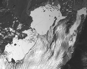
Tours of the Alaska Satellite Facility Control Room will also be available to show visitors how the dish atop the Geophysical Institute is manipulated by staff to capture data from polar-orbiting satellites. The tours run at 9:30 and 11:30 a.m. and 2:30 p.m. Staff from the Alaska Satellite Facility track and receive information from a number of satellites, including the Advanced Land Observing Satellite, which orbits about 500 miles above Earth. Images from ALOS have a slightly better resolution than Google Earth and are available for purchase.
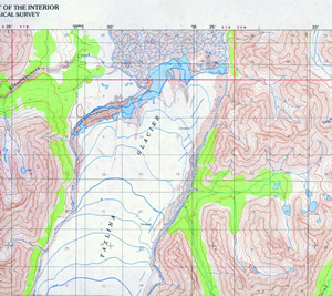
Scientists and students on the West Ridge have long used the collections of the three offices, but the information is also available to the public. Pilots, hikers, hunters and other enthusiasts can peruse aerial photos of almost any location in Alaska, purchase reproductions of vintage maps and current topographic maps, or order images of the state captured from an orbiting satellite.
Other products available from the combined centers include: National Geographic and locally produced maps of trails in wilderness areas; historical photos of Alaska glaciers and other geographic features; as well as satellite images for general interest, or for scientific study.
CONTACT: Debbie Dean, map office manager, at 907-474-6960. Rose Watabe, GeoData Center manager, at 907-474-7487. Rebecca Sanches, Alaska Satellite Facility user services office, at 907-474-6166.
ON THE WEB:
www.gi.alaska.edu/services/MapOffice/
www.gi.alaska.edu/services/geodata/
www.asf.alaska.edu/
Note to editors: Images are available upon request.