

Rasmuson Library archives acquires rare map
Rasmuson Library archives acquires rare map
Submitted by Carla Browning
Phone: 907-474-7778
01/06/09
Note to editors: e-mail newsroom@uaf.edu for a high resolution copy of the image.
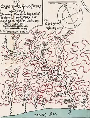
The Rasmuson Library’s recent acquisition of a rare map from the 1899 gold fields offers a glimpse of the past and the promise of fortune just prior to the gold rush on the beaches of Nome.
"This is supposed to be one of the earliest maps of the region, produced rather rapidly with the idea of attracting people into the area," said Tamara Lincoln, curator of rare maps and books at the University of Alaska Fairbanks Rasmuson Library. "It’s a whimsical, artistic and sometimes almost seemingly imaginary map of the region."
The library purchased the century-old map of the southern half of the Seward Peninsula--then called Cape Nome, Cape York and Bonanza Mining Districts of Alaska--in its original envelope. On the back of the envelope, advertising by the San Francisco-based J.S. Kimball Co. boasts ownership of several steamers, including its namesake, the "new fast clipper J.S. Kimball," described as 1,500 tons and with accommodations for 500 passengers.
The envelope copy attempts to persuade miners and other travelers to venture from San Francisco and Seattle to the gold fields. It offers prospective miners 550 safe deposit boxes in a vault at Nome. The company even offered trips to Siberia.
"The Bonanza Mining District, which is east of Nome, is by far the largest section of the map," said Terrence Cole, professor of history at UAF. "Historically, of course, that’s much less important than the Council area and Nome itself. This is not Nome, but Cape Nome, so it’s really before the Nome stampede."
Gustaf Nordblom, the map’s creator, is named on the map as a civil engineer. He studied art in Paris and may have operated under two names, said Lincoln. "He is a typical representative of the people that the Alaska gold fields attracted. He is cited here as a civil engineer, which tells me that throughout his lifetime he reinvented himself several times."
Rasmuson archivist Anne Foster first learned of the map while attending a historical meeting along with Laura Samuelson, director of the Carrie M. McLain Memorial Museum located in Nome. According to Foster, Samuelson was also interested in the map, but said the museum couldn’t afford to purchase it.
The Nome Map Co. sold the map for 50 cents in 1899, and nearly 110 years later, the university purchased it for $8,500 with funds from the Rasmuson Foundation. The map will be available to the public through the library’s digital archives and a display copy will be provided to the museum in Nome.
"We really do owe a lot to the Rasmuson Foundation and to the Rasmuson family, including Elmer Rasmuson, for whom our library is named, for giving us the resources to bring this back to Alaska," said Cole. "Elmer would have loved this map. Cartographers are a special breed of liar generally--imaginative folk who invent the world as much as represent it. And there is a lot of inventiveness in this."
About Alaska’s Digital Archives
Originally supported through a federal grant, the digital archives are now funded
by UAF, the University of Alaska Anchorage and the state library. About half of the
state’s rare maps have been digitized. In addition to rare maps, the digital archives
have also focused on other thematic areas. The first effort was to digitize images,
oral histories and documents related to the movement towards statehood. Visit vilda.alaska.edu for more information.
CONTACT: Anne Foster at 907-474-5590 or via e-mail at anne.foster@alaska.edu. Tamara Lincoln at 907-474-6671 or via e-mail at fftpl@uaf.edu.
CB/12-14-09/083-09