

Google Earth and Puff work together

Putting information about volcanoes in reach of the public is one of Peter Webley's main goals. As a postdoctoral fellow for the Arctic Region Supercomputing Center and the Geophysical Institute, Webley is working to make volcanic ash cloud forecasts viewable in 3D using Google Earth.
By using the Puff volcanic ash tracking model's web interface, anyone can create and view a two-dimensional simulation of an ash cloud. By accessing the Puff home page, a user can select a volcano, define weather parameters and set eruption data such as particulate volume and plume height. Once the Puff model input criteria are selected, the model generates a graphic which shows how the particles would scatter.
Webley is working to make volcanic ash cloud forecasts viewable in 3D using Google Earth.
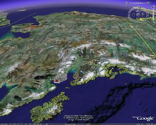
Once the 3D Earth-Browsing feature becomes available, users will also be able to view ash clouds and the surrounding areas using a Google Earth layer that reads data files from Puff forecasts and provides three-dimensional graphics which show a volcanic ash cloud's location, altitude and pattern of dispersal. Future developments will provide an operational three-dimensional view of the ash-plume's location and altitude. The Puff model tracks the latitude, longitude and altitude for thousands of scattering ash particles, which can then be displayed within Google Earth. By providing free modeling of volcanic ash clouds, Webley and his colleagues in the Earth and Planetary Remote Sensing group are able to share their monitoring of the geophysical events that shape our world.