

Spectro-radiometer
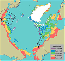
Image by Hilmar Maier/IAB/Alaska Geobotany Center
The Yamal Peninsula, upper left, and North American Arctic transects and associated bioclimate subzones.
A spectro-radiometer uses an optical sensor to measure the amount of radiation that is being transmitted in different wavelengths. Since the Earth and what lies on the surface do not emit shortwave radiation, scientists end up measuring radiation that is coming from the atmosphere (e.g. the sun) and what is reflected off of the land surface and the vegetation. Photosynthesizing green vegetation uses red light for photosynthesis, thus the red is absorbed and it doesn't reflect a lot of red light. However, green vegetation does reflect a lot of near infrared radiation. So, when near infrared reflectance is high and red reflectance is low, that indicates that there is a lot of green, photosynthesizing vegetation present. These measures of radiation reflectance are a relatively easy way to measure the amount of green vegetation without destroying any plant life in the process of collecting data.