Alaska benefits from growing number of seismic stations
September 23, 2015
Sue Mitchell
907-474-5823

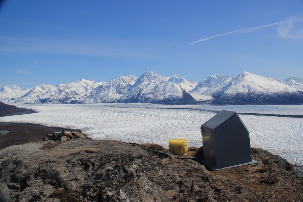
Alaskans can plan better for earthquakes following the installation of almost 90 new high-grade seismic instruments capable of measuring minute vibrations in the Earth.
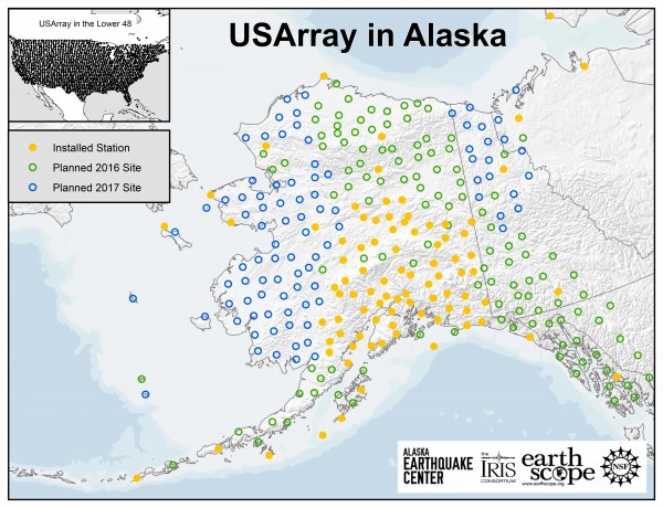
The instruments were installed in Southern and Interior Alaska as part of the EarthScope Transportable Array deployment, a $40 million, 5-year, temporary National Science Foundation-funded project. Scientists plan to eventually install about 260 sites.
“The ability to rapidly assess how big, what kind, and where an earthquake occurs is entirely dependent on the arrangement of stations recording it,” said Michael West, Alaska
state seismologist and director of the Alaska Earthquake Center at the University of Alaska Fairbanks.
The transportable array's instruments measure vibrations that are imperceptible to humans, gleaning immense amounts of information about the Earth. The statewide endeavor is assisted by the cooperative efforts of state and federal landowners, as well as the Alaska Native regional, village and tribal corporations working in partnership with the EarthScope project and Alaska Earthquake Center.
“Even during the short time the transportable array has been operational, we have seen tangible benefits to the state,” said Buzz Scher, chair of the Alaska Seismic Hazard Safety Commission. “Having a more focused knowledge of earthquake sources across the state will help geologists and seismologists better model Alaska’s seismic hazard. Better hazard models will result in more economical and resilient infrastructure planning for new pipelines, roads, schools and natural resource development.”
The project has also improved tsunami warning services.
“Alaska earthquakes are responsible for many of the country’s most damaging tsunamis,” said Paul Whitmore, director of the National Oceanic and Atmospheric Administration's National Tsunami Warning Center. “The new array provides information which improves the speed and accuracy of the center’s critical initial evaluation.”

The 2016 deployment will focus on the North Slope region of Alaska, while the 2017 deployment will look at western Alaska. These large regions have had limited, if any, seismic study.
“The existing stations are so spread out or nonexistent that we are missing information," Scher said. “The array will increase our information by orders of magnitude through the additional coverage. The longer the instruments are out, the better our ability to plan for damaging earthquakes.”
The temporary deployment will help to shed light on earthquakes in areas of the Arctic that are of tremendous recent interest for resource exploration and infrastructure development. Scientists also hope for insight into puzzling earthquake sequences, such as the 2014 Noatak swarm.
The university is seeking funding to continue operation of the stations after 2018; otherwise they will be removed.
ADDITIONAL CONTACTS: Michael West, 907-474-6977, mewest@alaska.edu; Buzz Scher, 907-646-9613; Paul Whitmore, 907-745-4212.
ON THE WEB: http://www.usarray.org/alaska
NOTE TO EDITORS: Additional images available on request. Contact Sue Mitchell, 907-474-5823, sue.mitchell@alaska.edu.


