Debris lobe creeps closer to Alaska's Dalton Highway
July 11, 2014

Rob Harper
907-474-7877
7/14/14
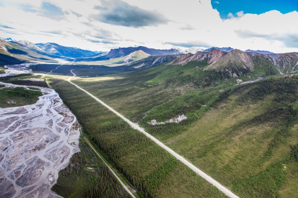
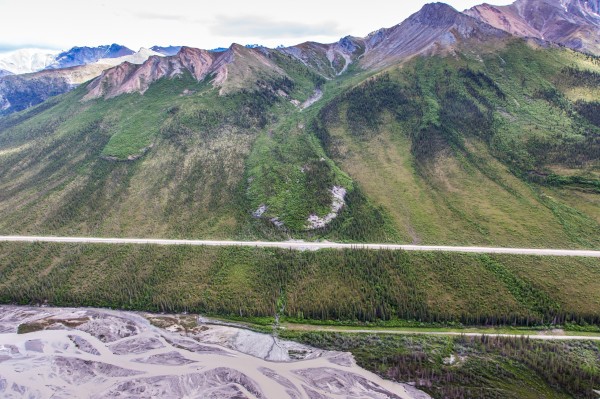
The leading edge of a frozen debris lobe in the central Brooks Range has crept to within 142 feet of the Dalton Highway, according to a measurement taken in June by university and state researchers.
If the massive blob of frozen rock and soil, known as Frozen Debris Lobe A, continues to slide at the average rate recorded on its surface, it could plow into the highway’s embankment in less than a decade. The Dalton Highway is the state's only road to the North Slope and its oil fields.
Margaret Darrow, associate professor of geological engineering at the University of Alaska Fairbanks, and Ronnie Daanen and Trent Hubbard, geologists with the Alaska Division of Geological and Geophysical Surveys, visited the lobe in mid-June. They hiked the lobe with a differential global positioning system unit to identify the locations of markers installed during previous visits. Then they compared the marker locations on June 19 to those recorded last year on June 20.
The readings showed that the lobe’s surface moved downhill at a variety of rates during the past year.
“It was moving faster at the upper area than it was at the toe,” Darrow said. “So it appears that it is thickening up.”
Near the bottom end of the lobe, where it is closest to the Dalton Highway, the movement averaged about 12.5 feet. Center readings averaged about 15 feet, though the rate varied widely across the lobe’s mid-section. Near the upper elevations, movement averaged about 20 feet.
Frozen Debris Lobe A is one of 23 such blobs that are less than a mile uphill of the Dalton Highway where it passes through the Brooks Range, according to earlier surveys conducted by the researchers. The lobes, made of frozen rocks and soil, slide down the mountainsides. They usually are teardrop shaped, with their narrow upper ends originating in small basins set just below ridgelines. The lobes move slowly enough that trees grow to maturity on their surfaces.

Scientists and engineers have not identified a method of stopping the lobes’ advance.
Using a combination of state and federal funding, UAF and state researchers have been investigating the lobes to understand how and why they move.
Drilling directed by Darrow and Daanen in 2012 found frozen silt, sand, gravel, rock and organic debris, as well as some liquid water, inside Frozen Debris Lobe A. They hit bedrock at 85 feet below the lobe’s surface. Sensors in the drill hole detected downhill movement of up to an inch per day above a shear zone deep within the lobe.
The state of Alaska, which maintains the Dalton Highway, decided earlier this year to move the road downhill about 400 feet to avoid the oncoming lobe. The trans-Alaska pipeline lies downhill another few hundred feet beyond the new road section’s planned route.
In June 2013, Darrow had tied a piece of blue survey ribbon to a spruce tree near Frozen Debris Lobe A’s leading edge to indicate a route with easier walking.
By this June, the lobe had knocked over and half-buried the spruce.
“It ate my marker tree,” Darrow said.
ADDITIONAL CONTACTS: Margaret Darrow, 907-474-7303 or mmdarrow@alaska.edu.
ON THE WEB: http://ine.uaf.edu/people/margaret-darrow/
NOTE TO EDITORS: Aerial photos of the debris lobe are available for download at //news.uaf.edu/debrislobe_july2014.
SB/7-14-14/009-15


