Scientists build a foundation for climate adaptation in Alaska
June 9, 2016
Kristin Timm
907-474-7064

Like the foundation of a house, the construction of a climate model is the product of thousands of small choices.
Whether it's placing the nails and leveling the blocks, or determining which module to include or how to treat a model discrepancy, every decision is essential when you are building a complex base that's sound enough to support something much bigger.
Led by scientists John Walsh, Uma Bhatt and Scott Rupp, a team at the University of Alaska Fairbanks International Arctic Research Center and the Scenarios Network for Alaska and Arctic Planning has undertaken a three-year effort to create a model that can better estimate climate and weather conditions across Alaska for the next 100 years.
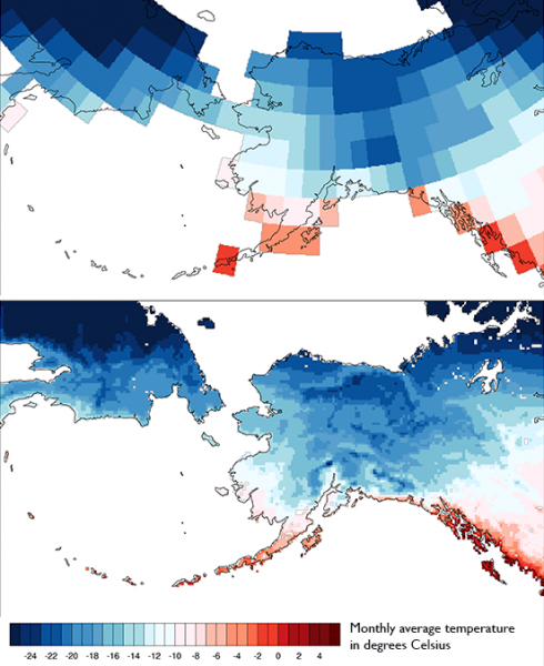
The dynamically downscaled model takes climate and weather information available at a large scale and transforms it to a smaller scale. In this case, the team takes global climate model information for an area approximately 150 miles on one side and downscales it to an area about one-tenth of that size. The downscaling process generates information useful for making decisions and adapting to the impacts of climate change on a local or regional scale, especially in coastal or mountainous areas that are not modeled accurately by coarse global-scale models.
Resource managers, planners and decision-makers across Alaska have been waiting in anticipation for this information as they try to understand how changes to temperature, precipitation and extreme weather events will affect the state’s natural resources, wildlife and infrastructure. For example, the dynamically downscaled data will be able to estimate the frequency of heavy rainfall events in the future. This information is valuable for planning the locations of culverts and other transportation infrastructure so that it is more resilient to future extreme weather events.
Similar information has been readily available for the rest of the United States, Europe and other parts of the world for the past decade. “The model provides the most locally relevant data for the state of Alaska,” explained Peter Bieniek, a member of the project team and a research associate at IARC. “We have laid the groundwork. Now we can develop new products that meet specific stakeholder needs.”

Joel Reynolds, the science coordinator for the Western Alaska Landscape Conservation Cooperative is interested in the model’s ability to estimate the frequency of rain on snow events in the future. These conditions can create a thick, icy crust that can limit a caribou’s ability to find food or cause them to expend more energy finding food, which can ultimately affect migration routes and subsistence hunting success. Reynolds’ organization, a cooperative of representatives from federal and state agencies and community members from each region of western Alaska, helps provide scientific results to land and resource managers.
“These events cannot be prevented," he said, "but this information can help wildlife managers and biologists understand how to manage wildlife populations if rain on snow events become more frequent in the future.”
The National Park Service is also excited about the new information. “We have 17 weather stations covering 19 million acres of NPS land in the northern part of the state,” explained Pam Sousanes, a physical scientist for the National Park Service. “That isn’t adequate when you are trying to understand local ecosystem processes. The downscaling helps us understand whether what we are seeing at the weather stations is happening throughout the entire National Park or Preserve.”
With so many potential needs and applications, why hasn’t this data already been produced for Alaska? Dynamical downscaling requires a more significant investment of time, expertise and computational resources than statistically downscaled data — which SNAP has produced for Alaska for nearly a decade. Statistical downscaling, however, is limited in its ability to forecast some of Alaska’s greatest weather challenges like rain on snow events, flooding, lightening storms or other extreme weather events.
Funding from the Department of Interior’s Alaska Climate Science Center has supported the expertise and computational resources needed to make the dynamical downscaling process possible. Producing modeled data for a 100-year period can take months on a supercomputer.
Before, during and after the model runs, there is a lot of work to do.
“It’s the ultimate mix of man and machine,” explained Bieniek. “Human decision-making is large part of the modeling process.” The scientists have to watch for errors and things that look abnormal and continually make adjustments to the model.
“You really need a background in meteorology, weather or climate — whatever is in the model — to recognize the things that don’t look right,” said John Walsh, IARC’s chief scientist. “It involves knowing the geography and the climate of Alaska, and experience helps you figure out what to do about the problems when they come up.”
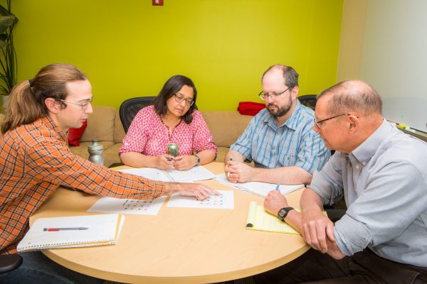
The weekly research team meetings often involve the team poring over a table of maps and diagrams, discussing the latest model outputs for variables like precipitation amounts per day for 50 or 100 years in the future. At one recent meeting Walsh noted how, “we can spot the variables that are ripe for application.”

However, applying the model to a specific decision-making process also takes time. “This process is a marathon and not a sprint,” explained Reynolds. “We’re getting closer to being able to work through identifying the impacts on these species and harvest management, but we need to get the right people talking to each other to make this work.”
Most scientific efforts require teams of people with diverse sets of skills and expertise, but the process of applying highly technical information to real-world decision-making may require something more. “We need a couple levels of people,” said Walsh. “You need someone who is technically strong and familiar with the model to talk to the stakeholder liaison who can figure out what’s needed out there. That’s something that scientists have not historically been so good at.”
“Working together is mutually beneficial. It strengthens the model and the application,” explained Sousanes. “The models help us understand what’s happening in the parks, and we’re collecting data from our weather stations that can help improve the models.”
Ongoing conversations are essential as these different groups of people work together to identify suitable questions to ask of the model and the data to aid in decision-making. “You have to be able to bridge the realities of the model to the kind of information that the user can work with,” Walsh said.
Building the dynamically downscaled climate model may have been a slow process for Alaska, but the effort is moving in the right direction. This work is a foundation upon which more challenging, real-world problems can be placed to frame our approaches to future climate change adaptation in Alaska.


