Signs of life in a place far away
August 28, 2012
ST. MATTHEW ISLAND — “Oh look, another tooth,” says Dennis Griffin, dressed in raingear and caked with wet soil.
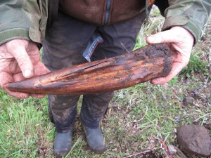
Griffin, the state archaeologist with Oregon’s State Historic Preservation Office, has traveled to one of the least-walked hillsides in Alaska to search for evidence of his species. On a tundra rise with a gorgeous view of Hall Island and a nice panorama of St. Matthew Island, he has today found a fox tooth in a decaying jaw, chips of rock where someone made tools, pottery, a plate-size anvil stone and a yellowed walrus tusk cut with deep grooves.

“I’m very glad I extended this plot,” Griffin says.
In two days of digging into a square depression on soft ground near where someone long ago dragged the 20-foot jawbone of a whale, Griffin has unearthed the leavings of Native people who probably lived on this lonely island around the time the Mayflower landed at Plymouth Rock. In foggy, wet weather typical for St. Matthew —more than 200 miles from the closest Alaska village — Griffin is gathering details that will help him flesh out why people lived in this place so far from any other known ancient encampment.
St. Matthew is an appealing place in summertime. With a beach just below, the incoming tide sets the table twice a day and seals pop their heads above water just offshore. Birds nest by the thousands on the island. They and their eggs would make for somewhat easy meals during the few months of summer. Four-hundred years ago, the island also might have featured polar bears, as it did in the late 1800s when mapmakers wrote that “large numbers . . . infest this island.” If a person’s weapons were adequate, the bears would also have been edible.
In winter, survival in a sod-covered hut dug into the ground would be another matter. Even today, in late summer, a chilly wind flows unchecked over the hillside. It’s hard to imagine standing here when sea ice covers the ocean and snow blasts over the landscape.
In his plot measuring a few feet by a few feet, Griffin has found dark soil where the occupants fired pottery from the local clay, but he wonders why he has not found a hearth in its usual spot near the back of the structure. He will ponder that question in more detail when he’s back home in Oregon.

For now, he’s happy with what he has found and what he also has dug up on Hall Island, now in view through the mist across Sarichef Strait a few miles to the northwest. There, when he and others were having difficulty finding the site, he followed his intuition and the words of Coquille tribal elder Don Ivy, who once told him, “A good place to live is a good place to live.”
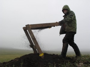
That directed Griffin to a bluff where scientists studying birds on Hall Island had chosen to pitch their tents. A few steps away, he found another square of tundra bursting with wildflowers. He began to dig and sift soil in the mist and fog and found spikes and nails he thinks are of Russian origin.
This discovery made him think of what he had read in The Seal-Islands of Alaska, written by Henry Wood Elliott, who had visited St. Matthew and Hall Island in 1874. Elliott described parties of Russians and their Aleut slaves, who had spent the winter of 1810-1811 on the islands. All of the Russians except one died of scurvy; Elliott reported that the Aleuts survived: “We found the ruins of the huts which had been occupied by this unfortunate and discomfited party of fur-hunters, who were landed there to secure polar bears in the depth of winter, when such ursine coats should be the finest.”
In addition to hearing about the possible location of the archaeological sites from biologist Dave Klein, who has visited St. Matthew six times, Griffin was further encouraged by a recent chance encounter at the Oregon State Fair in Eugene. There, he met a researcher with the National Oceanographic and Atmospheric Administration who told him of the existence of a map that is not in Elliott’s seal islands report. Less than one week before Griffin left Oregon to travel northward, the lovely hand-drawn document arrived as a PDF file. On the map, in addition to the note on polar bear infestation, is the word “Ruin” in the two places Griffin has dug on St. Matthew and Hall islands.
“I already had the locations thought out, but the map was the icing on the cake,” Griffin says.
With the dig artifacts soon to be stowed and then transported to the belly of the Tiglax — the 120-foot-ship run by the Alaska Maritime National Wildlife Refuge and one of the few ways to reach the island — Griffin will use his own time this winter to flesh out the lives of those who made Alaska’s most distant islands their temporary home.


