UAF gains increased computing power that can save lives
July 16, 2021
Rod Boyce
907-474-7185
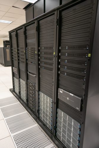
The computing cluster arrived at the UAF Geophysical Institute’s Alaska Satellite Facility earlier this year through funding by the National Geospatial-Intelligence Agency.

The addition of the high-performance computers marks a significant expansion of the Alaska Satellite Facility’s capabilities.
The computing cluster, given the name Athena after the Greek goddess of wisdom and war, is designed for processing terrain imagery obtained by satellites for the U.S. government. It will process image data faster and produce maps in greater detail than current systems and at a cost savings to the government.
“This is a powerful demonstration of how technology implemented at UAF can benefit the nation and emphasizes the importance of the Alaska Satellite Facility and the University of Alaska in making that benefit a reality,” said Nettie La Belle-Hamer, director of the Alaska Satellite Facility and UAF’s interim vice chancellor for research.
“Addition of the Athena computing cluster will bring additional jobs to UAF and Fairbanks, boosting Alaska’s economy,” La Belle-Hamer said. “We are grateful to the NGA for its commitment to Alaska and look forward to working with the GeoData Cooperative.”
The Alaska Satellite Facility is a part of the GeoData Cooperative, a collection of six public and private partners led by the National Geospatial-Intelligence Agency.

Having improved maps is important for civilian needs, such as rescue operations in natural disasters, and for military purposes, including humanitarian missions.
“At the end of the day, it's saving a soldier's life on the ground, it's saving people's lives when an earthquake happens, it's helping to do a rescue mission safer,” said Karen Diener, a National Geospatial-Intelligence Agency system engineering and technical assistant who has been in Fairbanks overseeing Athena for the agency.
The function of the Athena cluster differs notably from the Alaska Satellite Facility’s other purpose, which has been — and continues to be — the downlinking, processing, distribution and archiving of synthetic aperture radar data from NASA’s Earth Observing System satellites for use by public and private researchers and others.
“Athena isn’t downlinking the data; that's being done elsewhere,” said Helena Buurman, the Athena project manager. “We're taking the data and we're processing the satellite imagery, and we're creating the products. Athena is the central part of this workflow for the government.”
Diener said Athena’s arrival is a key component of fulfilling the National Geospatial-Intelligence Agency’s mission of providing global geospatial data and geospatial intelligence to support the Department of Defense, the intelligence community and the United States’ national security objectives. She added that it aligns with UAF’s designation by the department in 2018 as a University Affiliated Research Center, with the directive to perform research focused on geophysical detection of nuclear proliferation. The department’s designation was given to UAF’s Wilson Alaska Technical Center, one of 17 UARCs nationwide but the only one tasked with nuclear proliferation detection.
About the Alaska Satellite Facility
The Alaska Satellite Facility, with locations at UAF's Troth Yeddha' campus and off the Richardson Highway, marks its 30th anniversary this year. It operates the NASA archive of synthetic aperture radar data from a variety of satellites and aircraft, providing the data and support services to researchers in support of NASA’s Earth Science Data and Information System project. The Alaska Satellite Facility is one of 12 interconnected Distributed Active Archive Centers in that project.
About the National Geospatial-Intelligence Agency
The National Geospatial-Intelligence Agency delivers world-class geospatial intelligence that provides a decisive advantage to policymakers, military service members, intelligence professionals and first responders. NGA enables the U.S. intelligence community and the Department of Defense to fulfill the president’s national security priorities to protect the nation. NGA also anticipates its partners’ future needs and advances the geospatial intelligence discipline to meet them.
ADDITIONAL CONTACTS: Nettie La Belle-Hamer can be reached through the Geophysical Institute Public Information Office at 474-7185 or rcboyce@alaska.edu. Megan Jaffer, KD Geospatial Solutions, executive director, GeoData Cooperative, megan.jaffer@geodatacooperative.com
Approved for public release, 21-697


