UAF leads project to map hydrocarbon seeps on Alaska seafloor
November 21, 2019
Jeff Richardson
907-474-6284

Researchers from the University of Alaska Fairbanks are mapping oil and gas seeps off Alaska’s coast to better understand hydrocarbon resources and seafloor ecosystems. The work is being funded by the U.S. Bureau of Ocean Energy Management.
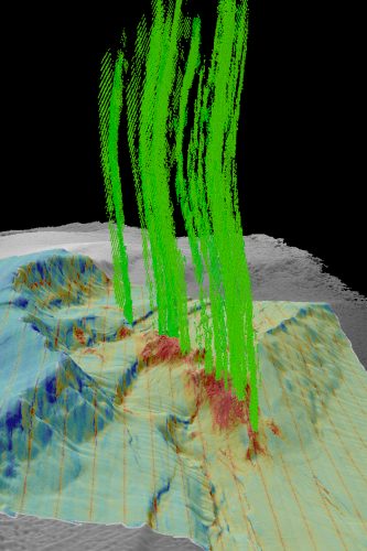
At hydrocarbon seeps, fluids leaking from the Earth’s surface carry hydrocarbon gases, primarily methane but also ethane and propane. The fluids, which sometimes include crude oil, may ooze out slowly or bubble vigorously into the ocean. On land, seep locations have traditionally been used in prospecting for petroleum deposits. In the ocean, they can also be used to help assess oil and gas resource potential, and their chemistry can provide an environmental baseline to distinguish natural environmental conditions from oil spills.
UAF oceanographer Jennifer Reynolds is leading the project in collaboration with Fugro, a geo-data specialist company with decades of experience in Alaska and a global expert in seeps mapping.
Onshore seep locations tend to occur in particular geologic rock types and along faults. The same is true offshore, where seafloor fault locations and geologic units are more difficult to determine. The patterns of seep locations provide information about the source of the fluids and give clues to the geologic pathways they follow up to the seafloor.
To map seep locations in the continental shelf off Alaska’s coast, the team is reviewing a century’s worth of reports, publications and data. Source information extends from the first days of Alaska oil and gas exploration a century ago through modern charting and fisheries surveys in Alaska waters.
“Every seep is important,” said Reynolds. “We’ll put all of them on the map and rate how confident we are about the accuracy of each location.”
Reynolds explained that some of the old documents contain vague descriptions of seep locations, such as “between these two valleys” or “in this certain bay.” Reports from modern oceangoing vessels, on the other hand, have precise GPS coordinates where seeps have been photographed or sonars have recorded bubble streams in the water above seeps.
“We’re interested in incorporating all of this information, but obviously some of these datasets are more precise than others,” she said.

The study also will enable researchers to review seafloor ecosystems around the seeps and learn about the nearby chemosynthetic biological communities, which use the hydrocarbons as a food source.
“There’s a possibility that some of the bacteria found near these seeps could also prove useful for oil spill remediation if they consume different chemicals that are emitted on the seafloor,” Reynolds said.
Fugro’s participation on the project is being led by geologist Kelley Brumley, a UAF alumna and seeps expert. Brumley and Reynolds are using the geology of the region to identify likely areas of additional seeps. They hope to check their predictions in future fieldwork at sea.
“Fugro is thrilled to partner with UAF on this project. We share a long record of collaboration with the university on both public and private-sector projects,” Brumley said. She also noted that mapping natural seeps allows industry to focus their oil and gas exploration activities on the most promising areas, thereby reducing the need for large-scale 3D seismic programs.
ADDITIONAL CONTACTS: Jennifer Reynolds, 907-474-5871, jrreynolds@alaska.edu; Kelley Brumley, kbrumley@fugro.com.


