

UAF researcher studies Alaska resources from afar
June 20, 2018
Debbie Carter
907-474-5406
Dave Verbyla has used remote sensing and geographic information systems to study shrinking boreal lakes, the breeding range of trumpeter swans, spruce beetle infestations, and the flammability of aspen and birch stands.
Verbyla, a professor of geographic information systems at the University of Alaska Fairbanks, specializes in analyzing natural resource trends associated with a changing climate. He likens remote sensing to looking at a historical photo series in which one can see how images have changed.
Verbyla said he likes working with GIS because of its capability to analyze and because he’s always been an analytical person, a trait that came from his mother.
“If anything broke, she was the one to figure it out and fix it,” he said.
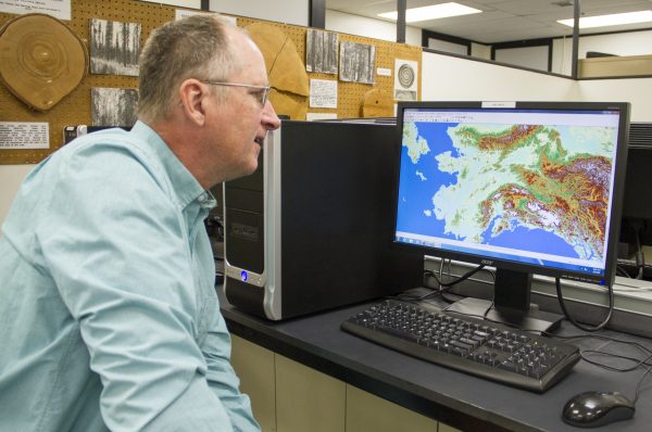
Verbyla taught himself how to use GIS while earning a doctorate in forest resources at Utah State University in the mid 1980s. The software had been around for a few years, but instructional classes were rare. GIS is a computer system for storing, checking and displaying all types of geographic data.
Compared to aerial photography, which is what he had been using, Verbyla said, GIS was a major advance. Information for his remote sensing research is collected by sensors, usually on satellites or aircraft, that detect energy reflected from Earth. The data is analyzed and mapped with GIS software.
He recently determined the elevation of spring snow lines in mid-May as part of a NASA-funded study with several other scientists that considered why Dall sheep populations have declined more than 20 percent rangewide since 1990. The decline was the worst in the western Brooks Range, where the population had dropped more than 70 percent.
Verbyla said the species is thought to be sensitive to spring snow conditions. If the snow line is at a lower elevation during the cold spring weather, sheep may be more susceptible to predators because forage above the snow line is lower quality and covered by snow. Below the snow line, sheep present an easier target for predators.
The professor analyzed the dynamics of the snowpack from 2000 to 2016 during the spring lambing season. He used satellite data to estimate the snow line elevation in 28 mountain areas from British Columbia to the Arctic in Canada and Alaska.
Verbyla said this was possible with the development of a regional remote sensing snow measurement tool, which provided daily images of 500-meter grids that showed whether snow was present.
When researchers compared their data to information from aerial sheep surveys, they found that fewer lambs survived when the snow line elevation was lower, and mortality increased with higher latitudes.
Verbyla, who grew up in central New Jersey, taught GIS at universities in New Hampshire and Idaho before coming to Fairbanks in 1993. A professor with the UAF School of Natural Resources and Extension, he teaches remote sensing applications in natural resources and provides GIS analysis for other researchers.
Todd Brinkman, a wildlife ecologist with UAF's Institute of Arctic Biology, has worked with Verbyla on several projects, including the Dall sheep research and analysis of how a changing environment affects hunter access to fish and game.
“He has a great command of what’s possible with spatial analysis today — and what’s not possible," he said. “I’ve always appreciated his pragmatic approach to things.”
Brinkman said Verbyla is also a willing resource when graduate students hit a roadblock with spatial analysis.
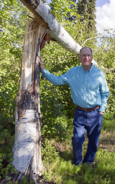
Much of Verbyla’s work has focused on boreal forests. A current project at the Bonanza Creek Experimental Forest near Fairbanks looks at how freezing winter rain affects white spruce mortality. He used a remote sensing method that relies on pulsed laser to identify trees in 2004 that were taller than about 100 feet, which, in Fairbanks, typically means white spruce. He studied data from the same one-meter grids 10 years later to determine which trees were missing. He spent two days on the ground confirming tree falls in 30 locations. In each case, he found fallen spruce trees that had been uprooted or their trunks broken.
“The spruce needles get iced up and the forest canopy gets very heavy,” he said. Even a small amount of wind can take the tree down.
Verbyla is looking at whether spruce that grow singly might be more vulnerable than trees growing in a cluster and whether trees at lower elevations are more or less susceptible to falling over. Learning about trees’ susceptibility is important in part because falling trees cause power outages, Verbyla said.
Verbyla is proud of former students who are using GIS for a variety of purposes. One works at Disney World and uses GIS to study traffic patterns. Another is mapping routes for mountain bikers. Others work for natural resource agencies.
While he’s still working on many research projects, Verbyla plans to retire next year and to spend more time with family, including an identical twin who lives in Virginia and is also a forester. He hopes to do more hunting, hiking and canoeing.
“I’m going to enjoy Alaska,” he said.