

University research in flight
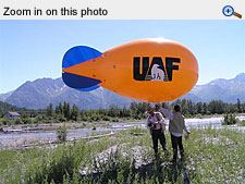
The BOB blimp floats above the Matanuska River white sweet clover study site. Standing on the riverbank are Norm Harris, left, and agricultural technician Beth Hall.

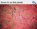
BOB photographed the white sweet clover study site on the Matanuska River on August 3, 2004. White sweet clover is a pinkish color at this time of the year, which makes it easy to map.
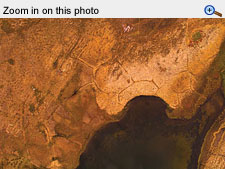
A view from BOB's digital camera of upland tundra near Galbraith Lake north of the Brooks Range showing typical features of permafrost soils including polygons, numerous thaw ponds and a pingo mound. A weather station and a square-meter target are also visible as tiny white specks at the middle left.
![]()
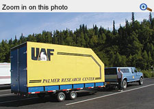
Norm Harris stands next to BOB's bright yellow trailer, custom fabricated at the Matanuska Experiment Farm by Mike Swanson. The trailer carries the fully inflated blimp, which can be rigged, sent aloft, used to acquire photos and then stowed away back in its trailer in as little as 20 minutes. This photo was taken on the way to the North Slope in 2004.
This view of a blackberry patch on the Oregon coast with a leaf rust infestation was taken at a height of 262 feet (80 meters).
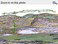
A computer graphic shows the path of the blimp as researchers shot photos of a gravel pit in Palmer from a height of 600 feet (183 meters). The blue dots represent points where the Canon camera took a picture and the red dots where the Olympus digital camera made an exposure.
By Deirdre Helfferich, School of Natural Resources & Agricultural Sciences (known today as the Institute of Agriculture, Natural Resources and Extension)
September 2005
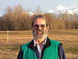
Norm Harris is an assistant professor of range science at the UAF experimental farm in Palmer.
Whenever the bright orange and blue blimp with the UAF logo on the side goes up, people stop and point. Airplane pilots fly by to check it out.
Scientists use the bi-camera observation blimp, commonly referred to as BOB, to take aerial photographs for research purposes. It aids researchers in the School of Natural Resources and Agricultural Sciences in studies of invasive weeds, forage production and riverbank ecosystems. Norman Harris, assistant professor of range management at the SNRAS experimental farm in Palmer, is responsible for developing the current incarnation of BOB and bringing it to Alaska.
"There are so many studies that can use this technology, you are only limited by your imagination," Harris says.
 The high resolution and excellent detail of BOB's low-level aerial photography aid
in a variety of uses. This summer researchers have been using BOB to study colonization
by willow, cottonwood and fireweed along the Matanuska River. They want to observe
the patterns as these and other plant species grow back after disturbances resulting
from fire, earthquake or use of earth-moving equipment. In these studies, the locations
of one-meter-square white PVC and metal targets are recorded with a global positioning
system or GPS. When the blimp is pulled across the sky, the scientists can use the
target points on the ground to line up multiple images for analysis. Harris and his
crew use the resulting points in the photos to create a mosaic. By comparing photos
of different areas they can monitor the spread of invasive plant species and see climate
warming reflected in changes in vegetation patterns. Photographing plant species in
summer while they are flowering makes it easier to identify and measure the coverage
area.
The high resolution and excellent detail of BOB's low-level aerial photography aid
in a variety of uses. This summer researchers have been using BOB to study colonization
by willow, cottonwood and fireweed along the Matanuska River. They want to observe
the patterns as these and other plant species grow back after disturbances resulting
from fire, earthquake or use of earth-moving equipment. In these studies, the locations
of one-meter-square white PVC and metal targets are recorded with a global positioning
system or GPS. When the blimp is pulled across the sky, the scientists can use the
target points on the ground to line up multiple images for analysis. Harris and his
crew use the resulting points in the photos to create a mosaic. By comparing photos
of different areas they can monitor the spread of invasive plant species and see climate
warming reflected in changes in vegetation patterns. Photographing plant species in
summer while they are flowering makes it easier to identify and measure the coverage
area.
Harris has used BOB to study canopy cover in agroforestry (land management for the simultaneous production of food, crops and trees), map stream structure and erosion patterns, and provide archaeological documentation. Once the images have been scanned for analysis and manipulation, they provide remote sensing specialists with data that can be used to monitor plant cover, plant population changes and distances between plant groups. Conventional aerial photography provides less reliable data and takes a lot more money, time and effort.
Researchers have used BOB in studies of forage production in fields and cattle pastures at the Matanuska Experiment Farm in Palmer. Pictures taken by BOB were used to inventory the building and facilities at the farm, as well as to create maps showing the buildings, pastures and forested area. Last year the farm sold gravel, and staff are now rehabilitating the gravel pit. BOB is helping to monitor the progress of the revegetation project.
 UAF Professor of Agronomy Chien-lu Ping recently took the blimp on a field trip to
the North Slope to study crypto-perturbation--patterns and formations in soil associated
with frost-churning and melting permafrost. These patterns include permafrost polygons,
thermokarst lakes formed by thawing of ground ice or permafrost, thaw ponds and pingos--low
hills or mounds forced up by hydrostatic pressure in an area underlain by permafrost.
UAF Professor of Agronomy Chien-lu Ping recently took the blimp on a field trip to
the North Slope to study crypto-perturbation--patterns and formations in soil associated
with frost-churning and melting permafrost. These patterns include permafrost polygons,
thermokarst lakes formed by thawing of ground ice or permafrost, thaw ponds and pingos--low
hills or mounds forced up by hydrostatic pressure in an area underlain by permafrost.
"We were able to get beautiful imagery of patterns in the soil on the tundra range along the Dalton Highway," Harris said.
Harris is also using BOB on a cooperative venture with researchers in Oregon to explore the potential of blackberry rust as a biological control, primarily for Himalaya blackberry, which is an introduced species that has become invasive in the Pacific Northwest. The blimp enables the scientists to easily map the range and growth habits of this exotic species.
Harris and Trish Wurtz of the Boreal Ecology Cooperative Research Unit have been working together to study white sweet clover, recognized as Alaska's most widespread invasive plant. Invasive plants can compete for nutrients and interfere with the growth of native plants, such as willow which is important moose browse, or disturb the ecosystem in other ways. Whether the sweet clover is a danger to native plants is unclear, but because the effects are unknown, just the fact that it is not native is considered a problem by some researchers.
A color infrared photo shows the acidic, wet tundra 27 miles south of Deadhorse. In the top middle of this photo Chien-lu Ping and Edmond Packee's Natural Resources Management soils field trip class can be seen digging a pit to collect samples.
Harris used the blimp to photograph the Matanuska River floodplain, identified by Jeff Conn of the USDA Agricultural Research Service as having a thriving infestation of clover. Wurtz will be conducting experiments on the ability of native shrubs and trees to withstand competition from the clover.
Harris' history with blimps dates back to 1993 at Oregon State University, where he used the earliest BOB to take aerial photographs to determine growth patterns around trees while studying forage production in agroforests. Harris then used a BOB to study sagebrush and grass communities in eastern Oregon and invasive plants along the Oregon coast. Once other researchers and students saw the results, BOB became quite popular. This led to a class about the use of blimps for monitoring riverbank ecosystems using geographic information systems. Fine tuning continues to improve the technology with new lenses for infrared, a smaller gondola and video links so the operator on the ground can see the scene viewed by the digital camera.
"This is the fourth blimp and camera setup I have been involved with," Harris said. "This one is unique for me in that it is the first equipped with both a digital camera and a conventional 35 mm camera."
In the near future, Harris and his colleagues will be expanding the white sweet clover study to include areas along the Tanana River and working on long-term plant population dynamics using the study site on the Matanuska River. They hope to develop a long-term study of the vegetation changes on the tundra range associated with climate change.
 "We would also like to take it to Nome and do some studies associated with the reindeer
research program," Harris said. Studies underway on the Seward Peninsula are looking
at how soil and plant relationships affect reindeer productivity. Reindeer in Alaska
forage year round over large ranges with minimal influence from herders. Spring and
early summer forage--primarily sedges and willows --provide the essential protein
and minerals needed for body and antler growth.
"We would also like to take it to Nome and do some studies associated with the reindeer
research program," Harris said. Studies underway on the Seward Peninsula are looking
at how soil and plant relationships affect reindeer productivity. Reindeer in Alaska
forage year round over large ranges with minimal influence from herders. Spring and
early summer forage--primarily sedges and willows --provide the essential protein
and minerals needed for body and antler growth.
Research tools like BOB can help scientists understand the effects of climate change as they are reflected in vegetation patterns--what grows where and when--and how those changes affect species like reindeer and caribou which depend on them.
For more information, please contact:
- Deirdre A. Helfferich, publications supervisor, School of Natural Resources and Agricultural Sciences, (907) 474-6923 or fndah3@uaf.edu
- Doreen Fitzgerald, information officer, School of Natural Resources and Agricultural Sciences, (907) 474-5042 or fndlf2@uaf.edu
- Norman Harris, assistant professor, School of Natural Resources and Agricultural Sciences, (907) 746-9467 or ffnrh@uaf.edu
Useful links:
- "Invasive plants creeping into Alaska," Ned Rozell (webpage no longer online)
- "Invasive Plants in Alaska: assessment of research priorities," Jeff Conn, Ruth Gronquist, Marta Mueller. Agroborealis, Winter 2003 (Vol 35, No 2)
- "Who is B.O.B.?" Connie Harris with Deirdre Helfferich. Agroborealis Winter 2003 (Vol 35, No 2)
- Matanuska Experimental Farm in Palmer
- The School of Natural Resources & Agricultural Sciences (Name change:Institute of Agriculture, Natural Resources and Extension)
- Boreal Ecology Cooperative Research Unit
- SNRAS Reindeer Research Program
